Entertaining Sandpoint: From Roller Skates to Moving Pictures

from-library-of-congress-page-see-source-in-notes

Women skating circa 1905. Library of Congress website reference cited below.

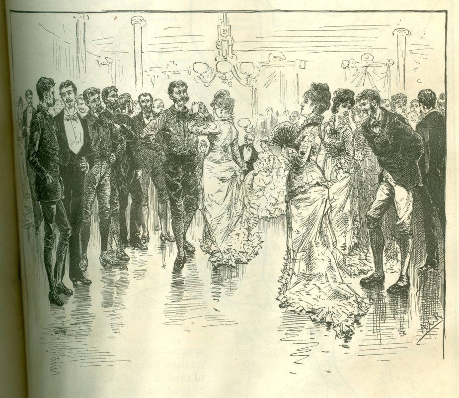
A roller skating fad swept the nation in the early 1900s, starting in eastern cities in 1905 and working its way to the west coast a year later. Seattle had three skating rinks by September 1906 and a fourth one was due to open later that month. The sport’s popularity had definite health benefits but it also was just plain fun.

img_4113

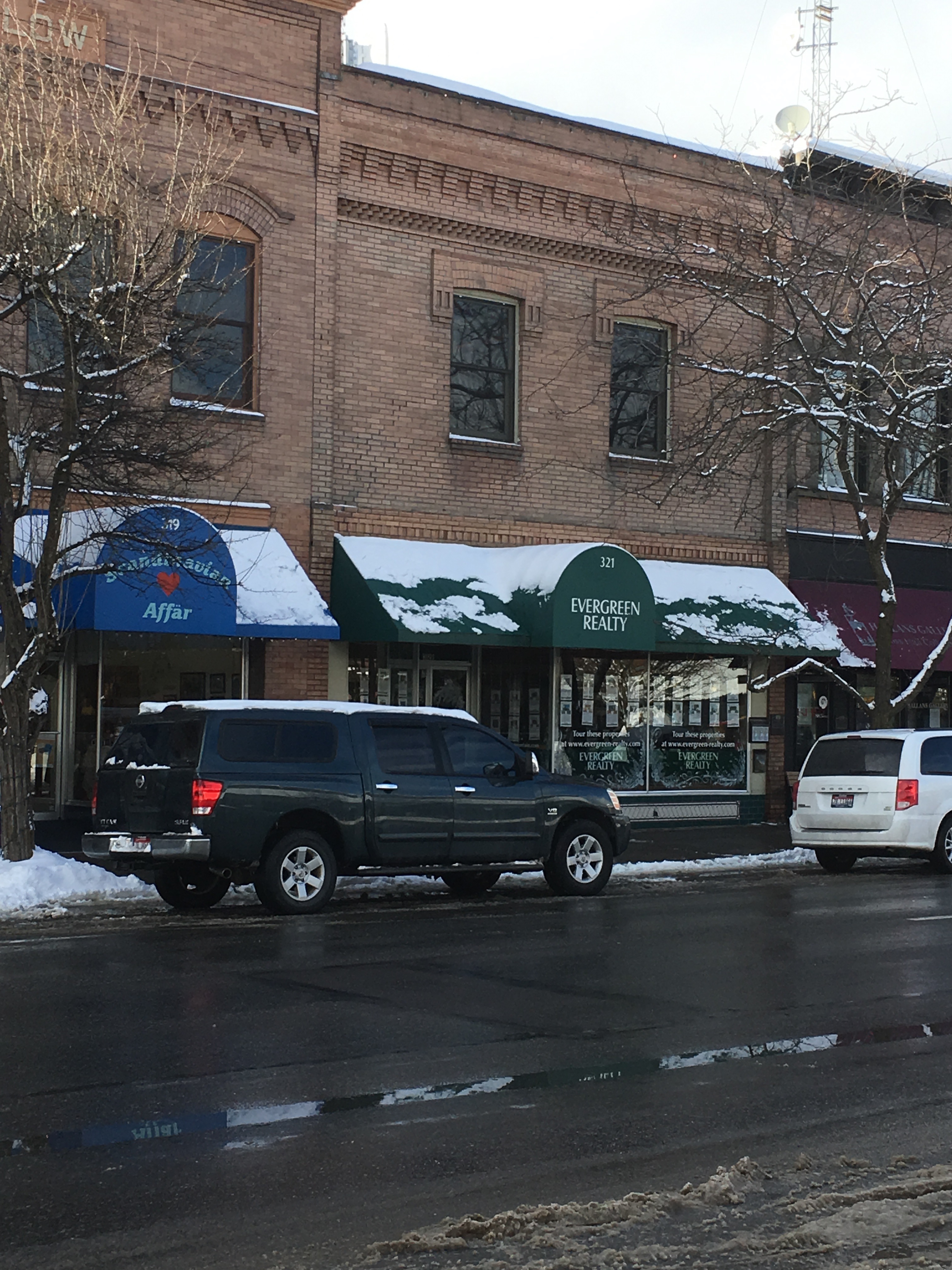
The Princess skating rink operated briefly on the second floor of the Star Market, where Evergreen Realty is today.

Sandpoint residents caught the skating bug when the Princess rink opened in the large room above the Star Market on First Avenue in early February 1907. It operated afternoons and evenings, and “ladies and children especially” were encouraged to skate at the earlier time. Admission was 10 cents and skate rental another 25 cents. Alas, the Princess had a short life —just two weeks, in fact. D.G. Lorenzi, owner of the neighboring building, got an injunction to stop the skating, declaring it a nuisance and damaging to his interests as a landlord. The district court eventually ruled in his favor, long after the Princess came to an end.

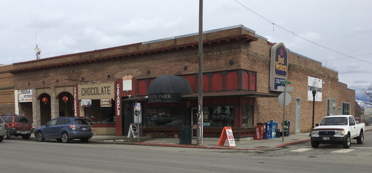
The same day that the newspaper noted the closure of the Princess rink, three well known businessmen (Thomas Martin, C.A. Olson, and J.H.C. Scurlock) announced their plans to build a large amusement center that would host roller skating, theatrical productions, and dances. Plans called for a frame building measuring 60 x 142, fronting on Church Street and extending to the alley at the rear. It was located just west of Second Avenue, approximately where the west half of the Kochava building is today.

img_4116

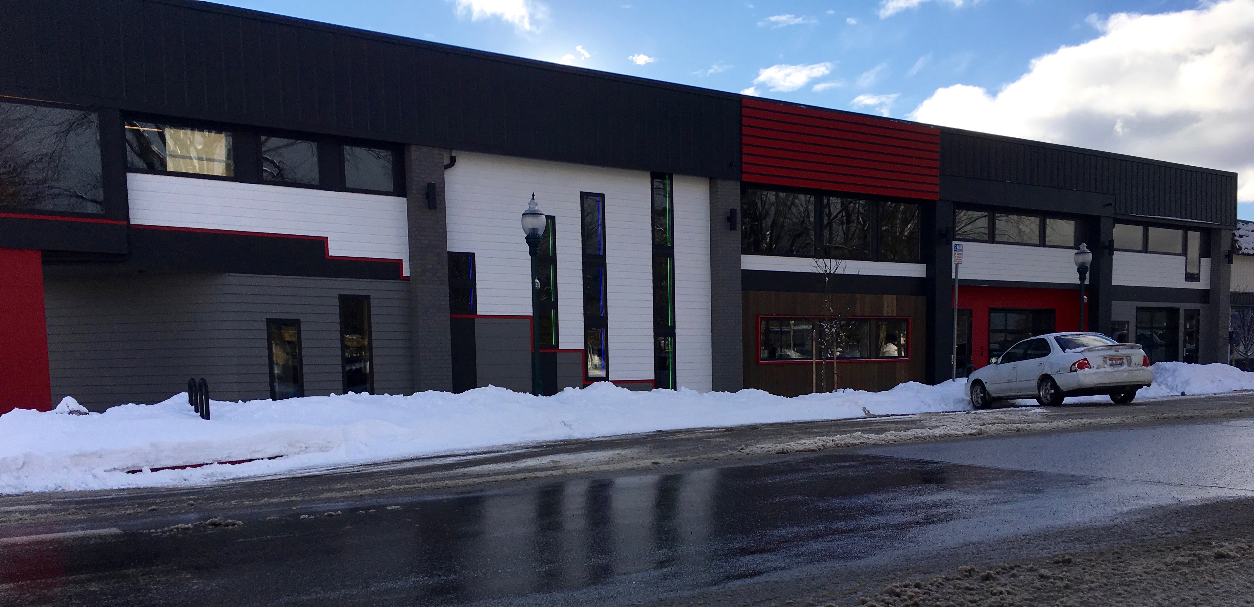
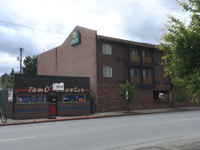
The Rink Opera House on Church Street stood approximately where the right half of this building is today.

Close to 800 people turned out for the gala opening of the new Rink Opera House on June 12, 1907. The hall was decorated with American flags and the five-piece Tucker orchestra provided music for the dance, hosted by the Eagles Lodge. Happy couples stayed until nearly 3 in the morning, fueled by the lemonade, cake, and ice cream served in the refreshment room.

1909-january-p10-rink

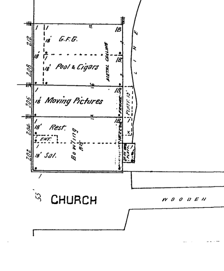
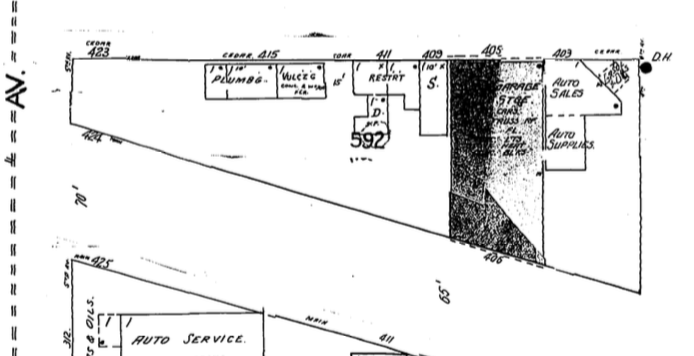
Rink Opera House as shown on Sanborn map from January 1909.

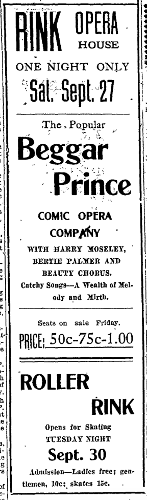
Roller skating became a seasonal activity at the Rink, popular during the fall, winter, and early spring. The management usually announced the season opening in mid-September, often noting that the skates had all been repaired and were ready for the season. Once in a while the Rink hosted special skating events such as the masquerade skating carnival in December 1911 when 200 people wore fanciful and comic costumes while circling the rink. Not long after that, Claude Langworth and Aubrey Finley competed in three heats to be the champion racer in Sandpoint. Langworth was declared the winner when Finley lost a skate in the twelfth lap of the final three-mile race.

With the advent of warm weather in the spring, skates were once again put away and replaced with a regular schedule of summer dances on Saturday nights. Other more formal dances were held throughout the year as well, usually sponsored by a community organization. For instance, the local Company A of the Idaho National Guard put on two dances over the Christmas holidays in 1911, with music provided by the Apollo Orchestra. The Rink military band, the “newest thing in musical wonders,” played for a dance in January 1908. The local newspaper noted that it was “a little bit loud but the time is absolutely perfect.”

1910-9-23-pdor-p5-c3-5-ad

Pend d’Oreille Review, 23 September 1910, 5:3-5.

1911-4-28-pdor-p5-c5-6-ad

Pend d’Oreille Review, 28 April 1911, 5:5-6.

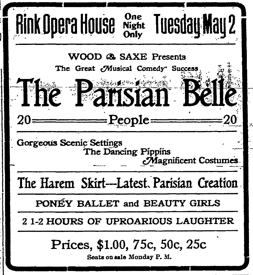
The Rink Opera House was used for much more than skating and dances, however. The 24×42 foot stage, with drop curtains, scenery, and four dressing rooms, provided space for touring vaudeville companies. Sandpoint’s location along three rail lines (two transcontinental and one regional) enabled the Rink management to book occasional touring vaudeville acts. Small venues like the Rink joined together in theatrical circuits to increase their clout with national touring companies. During the early part of the twentieth century, theaters throughout the Pacific Northwest worked with John Cort of Seattle who was affiliated with the New York booking agency of Klaw and Erlanger. The Rink had its new curtains and scenery, with artwork done by the Twin City Scenic Company of St. Paul, all ready for its first play, “The Black Hand,” which debuted on October 3, 1907. Later that month, a local production of “The Texas Steer” pleased the audience with “a very creditable” performance while raising money for the public school library. Such amateur plays proved popular over the years.

1913-9-26-pdor-p5-c5-ad

Pend d’Oreille Review, 26 September 1913, 5:5.

There were frequent musical events at the Rink that brought a wide variety of music to Sandpoint patrons. The Kellogg-Haines Singing Party performed in October 1907, with a variety of musical numbers including scenes from the light opera, “Dolly Varden.” A group of African American musicians, known as the Tennessee Jubilee Singers, combined humor with music to entertain the Rink audience in April 1908. Another time Swiss bell ringers demonstrated their skills with 120 Swiss bells, 64 musical glasses, 24 musical rattles, 81 triple-toned aluminum chimes, a silver quintette, a 5-octave steel marimbaphone, and more. (Phew!)

The Rink also provided a venue for a lectures and talks on wide ranging topics. Dr. Bancroft promised to scientifically explain various supernatural phenomena based on his interviews with “numerous spirits, spooks and phantasms.” The newspaper suggested, “Bring your rabbit’s foot.” A debate over prohibition drew raucous crowds in the saloon-heavy town in 1910. Henry George, Jr., was scheduled to speak on his theories of land taxation in March 1911 but did not make his appointment because his train was late; it is not known how many people had shown up at the Rink to hear him. Booker T. Washington, on the other hand, drew a large audience in March 1913 when he told the story of the famed Tuskegee Institute.

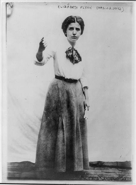
The Rink Opera House hosted numerous political speakers as well over the years. Former President Theodore Roosevelt packed the hall in 1911 and entertained the crowd with tales of his early experiences in North Idaho. Both Republican and Democratic speakers rallied supporters at the Rink from time to time, and Socialist orators proved very popular as well. When the Industrial Workers of the World (IWW) pushed to organize lumber workers around 1917, the fiery IWW speaker Elizabeth Gurley Flynn drew nearly 800 people to the Rink where she spoke passionately about labor issues. Just a month later, the Rink filled to overflowing with citizens who turned out to demonstrate their patriotism after the United States entered the war against Germany.

While musical and dramatic productions drew many Sandpoint citizens to the Rink, others came to watch a variety of sporting events like wrestling and boxing matches. One such match, between boxers Tim Hurley and Ed Cuff, did not end well when the crowd and referee recognized the fight as “a pure and unadulterated fake.” It was called after four rounds and the Rink refunded the ticket price.

Probably the most popular sport nationwide in the early twentieth century was baseball and Sandpoint was no exception. It was, however, a seasonal sport — that is, until the Rink opened its space to indoor baseball in 1915. Local men formed four teams, selected captains, and worked out a schedule of two games to be played every Sunday. They followed the rules established by large indoor leagues in eastern cities which called for a second shortstop to make ten players on each team. They also used a large soft ball and smaller bat to accommodate the restrictions of the indoor space. The men had to learn to adjust to the limited space, especially as the ball rebounded unexpectedly from the large rafters. The newspaper suggested that the low ceiling in the Rink accounted for larger than expected scores. The indoor league played again in 1916 but apparently stopped the following year.

Things were changing at the Rink by 1917. The skating fad had diminished, young men were leaving town to join the military, and the lumber industry was hit with a massive strike that paralyzed mills throughout the Northwest. Probably the biggest factor in its decline was competition from the two other theaters in Sandpoint which showed movies. In June 1917, the Rink’s manager asked the city council for permission to open a movie theater in the building, repeating his request from a year earlier. Evidently the council finally approved of the change.

1911-5-12-pdor-p8-c4-5-ad-movies

Pend d’Oreille Review, 12 May 1911, 8:4-5.

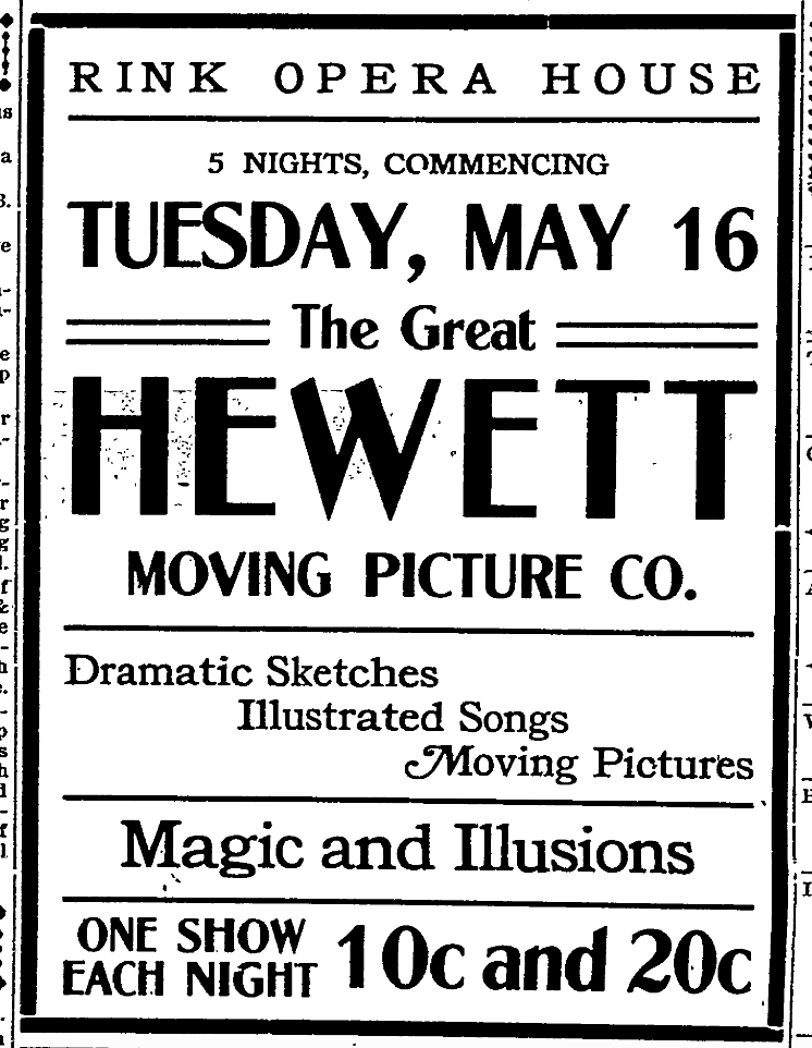
Despite the implication that movies would be a new feature for the business, the Rink had been showing occasional moving pictures since 1908. That year, the management marked the opening of skating season in September with an hour of movies preceding the skating. The Rink offered two nights of cameraphone pictures in April 1910, “pictures that talk, sing and act.” Billed as the first of its kind showing in Sandpoint, patrons were treated to David Warfield in “The Music Master” and “Dr. Jekyll and Mr. Hyde.” A few years later, the Hewitt Moving Picture Company played to large audiences in April 1913 with films on a variety of subjects including the ever-popular Buffalo Bill.

1921-august-p17-rinkliberty

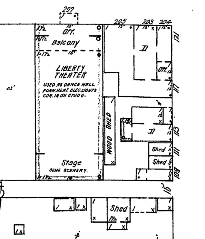
Liberty Theater, formerly Rink Opera House, as shown on Sanborn map from August 1921.

After these early forays into moving pictures, the old Rink was totally remodeled and transformed into the Liberty Theater in the summer of 1917. Seven boxes, fitted with comfortable rocking chairs, were built in the former gallery. New equipment promised patrons that movies would be seen without the flickering that was common during that period. The theater planned to show movies regularly, with occasional dances or “first-class road shows.” The grand opening of the Liberty featured the film, “The Last Man,” starring Mary Anderson.

Even this transformation could not save the Rink. The theater began losing money by at least 1917 and later was mortgaged. Then an early morning fire in mid-September 1922 spread from the frame building on the corner of Second and Church (the former Northwest Business College) to a nearby house, sheds, and the Liberty Theater. Despite the best efforts of the fire department, the buildings were a total loss. Owners of the Liberty estimated their loss at $13,000, with just $5,000 covered by insurance.

No trace remains of the once grand Rink Opera House where events entertained the people of Sandpoint for fifteen years. Today’s venues are larger and grander, from the 1927 Panida Theater to the open air Festival at Sandpoint. Despite the change in look and scale, the spirit and intention of the Rink Opera House remain, bringing people together through the arts.


Note: It’s true: Great minds think alike. When I started researching this post in December, I had no idea that Cameron Murray, curator at the Bonner County Historical Society, was also gathering information on the Rink Opera House. I tip my hat to Cameron for her good article on the Rink, recently published in the Co-Op Country Round Up newspaper. The museum is planning its annual History Mystery fundraiser, “A Vaudeville Review,” based on the Rink. If you want a good time, plan to attend on February 25. Call the museum at 263-2344 for more information.

Sources cited:

“Latest Fad Is The Roller Skate Two Step,” Seattle Star, 1 September 1906, 1:4-5; https://www.loc.gov/rr/news/topics/rollerskating.html; “Princess Rink,” Pend d’Oreille Review, 7 February 1907, 8:2; “The Princess Rink,” Pend d’Oreille Review, 7 February 1907, 8:4; “Judge Woods Finds For Lorenzi,” Pend d’Oreille Review, 18 December 1908, 16:3; “Big Rink Is Opened,” Pend d’Oreille Review, 13 June 1907, 1:5; Pend d’Oreille Review, 18 September 1908, 5:2; Pend d’Oreille Review, 29 September 1911, 5:1; “Many Attend Skating Carnival,” Pend d’Oreille Review, 22 December 1911, 10:2; “Decide Championship Saturday,” Pend d’Oreille Review, 19 January 1912, 5:4; “Langworth Wins Skating Race,” Pend d’Oreille Review, 26 January 1912, 1:5; Pend d’Oreille Review, 28 April 1911, 5:3; Pend d’Oreille Review, 29 September 1911, 5:1; Pend d’Oreille Review, 10 January 1908, 5:2; Holly George, Show Town: Theater and Culture in the Pacific Northwest, 1890-1920 (Norman: University of Oklahoma Press, 2016), 115-123; Pend d’Oreille Review, 26 September 1907, 5:3; “Twas a Fine ‘Texas Steer,’” Pend d’Oreille Review, 17 October 1907, 1:2; “Kellogg-Haines Singing Party,” Pend d’Oreille Review, 17 October 1907, 1:4; “The Tennessee Jubilee Singers,” Pend d’Oreille Review, 17 April 1908, 1:6; Pend d’Oreille Review, 30 April 1909, 2:4; “Hoodoos,” Pend d’Oreille Review, 23 April 1909, 3:3; “And the Greatest of These Is Charity,” Pend d’Oreille Review, 27 May 1910, 2:2; “Sam Small Debates,” Pend d’Oreille Review, 27 May 1910, 6:1-5; “Henry George, Jr., To Lecture,” Pend d’Oreille Review, 3 March 1911, 1:4; “Henry George, Jr., Fails to Arrive,” Pend d’Oreille Review, 17 March 1911, 4:5; “Negro Educator To Lecture,” Pend d’Oreille Review, 7 March 1913, 3:3-4; “Solving Of Negro Problem,” Pend d’Oreille Review, 14 March 1913, 3:4; “Bonner County Greets Roosevelt With Mammoth Crowd,” Pend d’Oreille Review, 14 April 1911, 1:1-6; “Senator Borah Tonight,” Pend d’Oreille Review, 28 October 1910, 1:2; “Eugene Debs to Lecture Here,” Pend d’Oreille Review, 12 May 1911, 1:4; Pend d’Oreille Review, 9 June 1911, 10:2; “I.W.W. Bring Their Big Drawing Card,” Pend d’Oreille Review, 9 February 1917, 1:5; “Community Responds to Country’s Call to Arms, Pend d’Oreille Review, 30 March 1917, 1:1-6; “Tim Hurley and Ed Cuff to Box,” Pend d’Oreille Review, 17 April 1908, 1:3; “Bum Fight A Fake,” Pend d’Oreille Review, 24 April 1908, 1:1; “Miller Wins The Bout,” Pend d’Oreille Review, 20 February 1914, 3:1; “Will Play Indoor Baseball,” Pend d’Oreille Review, 15 January 1915, 1:6; “Arrange Indoor Schedule,” Pend d’Oreille Review, 22 January 1915, 1:4; “Panhandles Step Into Lead,” Pend d’Oreille Review, 19 February 1915, 3:4; “Panhandles Cinch Pennant,” Pend d’Oreille Review, 5 March 1915, 1:1; “First Games Next Sunday,” Pend d’Oreille Review, 29 October 1915, 1:6; “City Council Gets Through Some Important Business,” Pend d’Oreille Review, 21 July 1916, 8:3; “Council’s Stroke of Economy To Do Away With Crosswalks,” Pend d’Oreille Review, 22 June 1917, 8:1; Pend d’Oreille Review, 18 September 1908, 5:2; Pend d’Oreille Review, 15 April 1910, 7:4; “Special At Rink Opera House,” Pend d’Oreille Review, 15 April 1910, 12:3; “Good Picture Show Coming,” Pend d’Oreille Review, 12 May 1911, 8:2; Pend d’Oreille Review, 18 April 1913, 5:3;   “New Show House Opens Next Tuesday,” Pend d’Oreille Review, 21 September 1917, 1:6; “Old Landmarks Are Destroyed By Fire,” Pend d’Oreille Review, 15 September 1922, 1:1; https://www.loc.gov/rr/news/topics/rollerskating.html; maps of Sanpoint, Idaho, Sanborn Map Company (New York: New York City), January 1909:10, August 1921:17.

Advertisement
Posted in Uncategorized | Tagged , , , , , , , | 2 Comments

Tales from a Lonely Cabin

img_3651The cabin has seen better days for sure. In fact, with the roof collapsed and windows gone, I doubt if even mice live there any more. The setting is beautiful, however, in an open field between the base of a forested mountain and the banks of the Pack River. On a sunny day in late summer, it seemed like an ideal place to be.

img_3663

Looking into cabin through front door.

I’ve wondered about this cabin for years. If you look to the east at just the right spot on the Lower Pack River Road, when the leaves are off the trees, you can catch a glimpse of the tiny cabin set at the base of the distant hill on the far side of the river.

As I set out to write about this cabin, however, I kept getting bogged down. I finally realized that I see this particular story in multiple layers. There’s the just-the-facts-m’am research into the family that lived there; there’s the story about making assumptions based on too few of these facts; and there’s the story of “institutional memory,” how research for one project can apply to a totally different one decades later. I’ll wander through these layers in reverse.

img_3660Back in 1977, while researching old homesteads on the Sagle Peninsula, Robert Newington told us that a man named Bob Nelson had built the two small log cabins on his parents’ homestead. Nelson was from Nova Scotia and was “a wizard with an axe and broadaxe,” Newington wrote. After selling his homestead right to Newington’s father, Nelson and his young wife moved to the Pack River neighborhood sometime in the 1890s. Bob Nelson’s name stuck in my mind and I thought of him occasionally when I noticed the lonely cabin in the distance.

glo-map-t58n-r1e-jan-1903

Part of General Land Office map, surveyed in 1901, printed in 1903.


After seeing the little log cabin in person, I wanted to know if this was really Bob Nelson’s home. A search through land records showed Robert B. Nelson did indeed homestead a nice piece of land along the Pack River, just south of the confluence with Trout Creek. His claim for nearly 160 acres, approved in July 1905, included not only the field where the cabin and log outbuilding are located but also a large open field across the river.

I also delved into census and marriage records available at the LDS Family History Center on Schweitzer Cutoff Road. I learned that Robert and Agusta Nelson married at Garfield Bay on January 31, 1895, when she was just 20 and he was 35. Their first child, Lovell, arrived before the end of the year and others followed in quick succession: Fremont (1897), Bell (1899), Archie (1900), Maude (1902), and Florence (1904). Most likely complications set in after this last birth and Agusta died on March 10, 1904, when Florence was less than two weeks old. She was buried in the Hope cemetery.

img_3620Now here’s where my assumptions initially led to the wrong conclusions. When I looked at the small log cabin and thought about a family with six children there, I assumed that they must have been poor. In fact, I couldn’t even imagine how they could all fit in such a small building. Following my incorrect assumption, I went to the Hope cemetery thinking that I might have trouble finding Agusta’s grave. Instead of a modest marker, however, I found a large granite monument, larger than those on the surrounding graves. Clearly this family was not poor.

That’s when I began to look for evidence of a larger home on the property. I could find no written records, but newspaper articles did describe Bob Nelson as a “well to do farmer near Hope.” A.J. Helgenberg at the Forest Service office in Sandpoint dug out aerial photos of the lower Pack River area taken in the mid-1930s, and these at least partially solved my question. A careful look shows that there was a large L-shaped building near the cabin, most likely the home where the Nelson family lived. There is no way to know, of course, just when this house was constructed but I like to think that the Nelson family lived in some comfort.

screen-shot-2016-11-22-at-11-34-31-am

Part of 1913 Forest Atlas map showing highway crossing Pack River just below Nelson home in Sec. 31.

Looking at the remote location of the Nelson’s cabin, accessible today only by a trail along the river, it’s easy to make the assumption that this was always the case. Once again, a bit of research into old maps shows that this was definitely not true. The original highway connecting Sandpoint and Clark Fork crossed the Pack River just a short distance south of the cabin. While the bridge is long gone, there is a small dock on the east bank at the original crossing. Standing there, you can still see some of the pilings in the river.

Setting aside incorrect assumptions, the facts show that the Nelsons had experienced tragedy even before Agusta died. While living near Kootenai late in 1903, little Maude, then just 18 months old, wandered onto the railroad tracks and was hit by a train. While seriously injured, the little girl survived. Bob Nelson later sued the Northern Pacific but I did not find any resolution of the case.

Three years after Agusta died, Bob Nelson married Matilda McLaughlin, a widow from Rawlins, Wyoming. She was close to Nelson’s age and may have brought at least one of her four children into the large blended family. The marriage did not last, however, and Bob and Matilda were living separately by 1910, Bob with his six children at the farm on Pack River and Matilda in a rented home in Hope.

Robert Nelson filed for divorce in 1916 but for some reason this was not finalized until 1923. Nelson sold his farm in 1919 to Edmund W. Wheelan for $2,175, subject to a $2,000 mortgage to the Federal Land Bank. Wheelan resold the property just over a month later for $3,000. Bob Nelson returned to Canada with three of his children in 1919. He died five years later in Pouce Coupe in the Peace River region of British Columbia. He was 64.

Bob Nelson left Bonner County nearly 100 years ago but his lonely cabin reminds me that real people lived and died here, men and women worked hard on this land to support their families, children played in the sunshine and the snow. I also am confident that there is much more to the Nelson story that I will never know.


Sources:  Robert Newington to Thomas Renk, 27 March 1977, pp. 6-8, on file, Flume Creek Historical Services; Map of Township No. 58 North, Range No. 1 East of the Boise Meridian, Idaho (Boise City: Surveyor General’s Office, 26 January 1903); Bonner County, U.S. Patent Homestead, Book 1:451; Western States Marriage Records Index, Marriage #7794, recorded in Kootenai County, Book B:268; Lovell B. Nelson, Idaho Death Index 1890-1964, Certificate No. 114652; Fremont Sevell Nelson, Idaho Birth Index 1861-1914, Certificate No. D60-0195; Bell Emeleme Nelson, Idaho Birth Index 1861-1914, Certificate No. D54-0528; Archie Nelson, Obituary Daily Times Index, 1995-Current; Maude Nelson, Idaho Birth Index 1861-1914, Certificate No. D54-0975; Florence Nelson, Idaho Birth Index 1861-1914, Certificate No. D70-0260; “Mrs. Robert Nelson Dead,” Northern Idaho News, 11 March 1904, 3:3; “Hope Brevities,” Northern Idaho News, 8 December 1905, 4:1; Forest Atlas, Sheet 12 (Missoula: US Forest Service, 1913); “Little Child Is Struck By An Engine,” Northern Idaho News, 6 November 1903, 1:3-4; “District Court Term To Be Extended One,” Northern Idaho News, 3 February 1904, 7:1-4; Idaho, County Marriages, 1864-1950, 004533535, frame 275 of 702; Twelfth Census of the United States, 1900, Wyoming, Fremont County, Split Rock, Roll 1826, page 7A, Enumeration District 0029; Thirteenth Census of the United States, 1910, Idaho, Bonner County, Hope Precinct, Sheet 2A and 8A; Robert Nelson v. Matilda Nelson, Divorce Suit 1761, 1916; “Many Cases Disposed Of In District Court,” Pend d’Oreille Review, 4 October 1923, 1:6; Bonner County, Deed Record, Book 35:45, Book 36:164-165; Border Crossings: From U.S. to Canada, 1908-1935, Roll T-15313; British Columbia, Canada, Death Index, 1872-1990, GSU No. 1927302.

Posted in Uncategorized | Tagged , , , , , | 10 Comments

Entertaining Sandpoint: The Old Maids’ Convention of 1902

fullsizerender1

The “new” Knights of Pythias hall, completed in 1915, replaced the earlier frame K.P. hall that had been on the same site since ca. 1901. The Old Maids’ Convention was held there in the upstairs meeting room in 1902.

My interest was piqued by a small news item on the front page of the newspaper inviting “widowers and bachelors” to attend the first convention of the Old Maids’ Association. While single men were the target audience, the public also was welcome to attend the meeting on October 25, 1902, at the Knights of Pythias hall, a large frame building on the corner of Second and Main in Sandpoint.

Sanborn map, 1904:4.

Portion of map of Sandpoint, September 1904 (Sanborn Map Company). The Knights of Pythias hall was the frame building labeled on the map as “Opera Ho[use].”

One week later a larger article provided more information on the upcoming event. The 16 women in the Old Maids’ Association, ranging in age from 14 to 24, hoped to correspond with eligible bachelors and widowers “between the ages of 16 and 90 with a view to matrimony.” They claimed that they were all “exceptionally handsome women” and were perplexed that their beauty had yet to be recognized “by the sterner sex.” They offered to exchange tin types and locks of hair but asked that “the latter be returned for future use.” The notice was signed by Rebecca Petrace, secretary and treasurer of the association.

The day before the big event another article revealed the truth: The Old Maid’s Convention was a one-act comedy and most of those depicting the “old maids” were actually married women. The cast of creatively named characters included Minty Clovertop, Desire A. Mann, Hepalbah Odelia Olds, May Haverman, Petunia Pickles, Charity Hopegood, Serena Hasben, Anxiety Doherty, Eliza Hooker, and Prof. Makeover. The play hoped to depict the real lives of “old maids,” including “their true aim and ambition in life.” General admission for the public was fifty cents, with children under 12 at half price.

The play was well attended and, judging by the laughter, was deemed a huge success. The women were complimented especially on their makeup, and the newspaper suggested that their acting showed excellent training for their roles. Rev. J.C. Reed also was pleased since the entertainment raised $84.50 to benefit him and the Methodist Episcopal Church in Sandpoint.

Did Desire ever find her man? More than 100 years later, inquiring minds still want to know!


Sources cited:

“Local Brevities,” Kootenai County Republican, 10 October 1902, 1:3; “Notice to Widowers and Bachelors,” Kootenai County Republican, 17 October 1902, 1:5; “The Old Maids’ Convention,” Kootenai County Republican, 24 October 1902, 1:5; “Old Maids’ Convention,” Kootenai County Republican, 31 October 1902, 1:5-6; Map of Sandpoint, Idaho (New York: Sanborn Map Company, September 1904), 4.

Posted in Uncategorized | Tagged , , , | 2 Comments

Sandpoint Farmers’ Market

IMG_2984

It was a warm spring morning, the first Saturday in May, and I heard the marimba music several blocks away. The joyful sounds drew me to Farmin Park where I found the grass and surrounding streets filled with vendors selling early veggies, cut flowers, and loads of bedding plants. There were crowds of people there for the first day of the Farmers’ Market at Sandpoint, buying food, visiting with friends, and dancing to the music, all celebrating the start of our glorious North Idaho spring and summer.

The market is going strong now, growing steadily from its small start in 1988 when just a handful of vendors gathered to sell garden produce. It was the brainchild of Lois Wythe, a master gardener who somehow knew that our area was ready for this type of venture. She printed flyers announcing a meeting and was surprised by the large crowd that showed up. Additional meetings followed to fine tune the plan, establish rules, and set the opening date for May 14, 1988, in Farmin Park. The location has remained the same but the market has expanded with booths filling the park and overflowing into and across Oak Street. It has become a vibrant part of the community and I’m sure that Lois would be immensely pleased.

I’ve enjoyed the Farmers’ Market for 28 years now and always assumed that it was a modern idea, a way to connect small-scale farmers with people who wanted tomatoes so fresh that they still held the warmth of the summer sun. I was surprised then, while researching a different topic, to find references to another farmers’ market, and I knew that someday I would have to find out more.

It turns out that the first Farmers’ Market took place just over 100 years ago, on the Tuesday before Thanksgiving in 1915. Members of the Sandpoint Commercial Club had suggested the market idea as a way to encourage agriculture in the surrounding region. Sandpoint was a lumber town then, but huge tracts of land had been clearcut and were being sold as “stump ranches.” Farmers were gradually improving this land and needed to find markets for their products. In turn, local merchants understood that any money earned by the farmers would be spent at stores in town so they supported the idea of this market.

The first farmers' market opened in late 1915 in a vacant store on the first floor of the St. James Hotel. The Pend d'Oreille Winery now fills the same space with a tasting room and gift shop.

The first farmers’ market opened in late 1915 in a vacant store on the first floor of the St. James Hotel. The Pend d’Oreille Winery now fills the same space with a tasting room and gift shop.

Since it was late November, the Commercial Club got permission to use a vacant store on the corner of Cedar and Third. The weather did not bode well. A foot of wet snow fell overnight and gray clouds on market day delivered a steady drizzle of rain. When the first customers came around 10, there were no farmers in sight. Things picked up soon, however, when C.E. Davis arrived with cabbages, carrots, and nearly 160 pounds of dressed pork from his farm near Ponderay. Customers eagerly bought most of his pork within the next few hours. A second farmer failed to sell any of his live piglets, but the other two vendors did well with their celery and cabbage, sauerkraut, canned vegetables, crisp doughnuts, mincemeat, butter, and dressed chickens and geese. Despite the small showing, Mr. Davis was enthusiastic about the market, which he had been trying to establish for months. The local newspaper reported favorably that “this small beginning would seem to show that if the farmers will take hold of the idea the townspeople will get in and help by patronizing the market.”

The Krebs Building that once housed Kerr & Nead Grocery as well as the Economy Grocery.

The Krebs Building once housed Kerr & Nead Grocery as well as the Economy Grocery.

The market location changed in December when Kerr & Nead Grocery offered to let the farmers use the vacant store adjacent to the grocery in the Krebs Building, on the corner of Pine and Second. Farmers continued to come once a week into December 1915, increasing to every day just before Christmas. Mr. Davis encouraged vendors to standardize their produce, making sure that everything was clean, sorted, graded, and displayed attractively. He believed that the market experiment had been “a very successful beginning.”

The farmers’ market then apparently went dormant for nearly three years until the idea was revived, this time with both state and local backing. Charles Waggoner came to Sandpoint in early September 1918 to encourage local farmers to participate in a new market. He had been organizing similar ventures around North Idaho as part of his work with the state bureau of farm markets. While here, Waggoner met with members of the Sandpoint City Council to get their backing for a new farmers’ market. City officials were quick to back the proposition and agreed to lease the vacant lot between Cedar and Main Streets, just east of the Spokane International tracks, where La Quinta Inn stands today.

Less than two week later, the Sandpoint farmers’ market opened on a Saturday morning with great success. Mrs. Emma Weaver had twenty-five varieties of fruits and vegetables for sale, garnering her first prize – a $3.50 pair of shoes from J.A. Foster & Co. Joe Sitko won the second prize for his fourteen different kinds of fresh produce. The market, which was open every Wednesday and Saturday morning, continued to draw both buyers and sellers. Farmers sold seventeen loads of produce one morning in October, despite the cold and rainy weather.

The market gained stability through active participation and encouragement from city officials, the Bonner County Farm Bureau, and the state. The city council passed special ordinances to regulate the market and began looking into securing a permanent location. Edgar Ludwick, the county farm agent, pushed for regulations, not only to ensure a clean market area but also to limit the number of sellers so that the supply of perishable produce did not exceed the demand.

Krebs Building on the corner of Pine and Second.

Krebs Building, home of Kerr & Nead as well as Economy Grocery.

Cold weather drove the market indoors by January 1919. Growers once again were back in a vacant store in the Krebs building on the corner of Second and Pine, next to the Economy Grocery. This was only a temporary solution, however, because others were working to build a row of booths on the vacant city lot where this market began. The 24×62 foot structure, located on Cedar Street just west of today’s Tam O’Shanter (better known as the Tervan), had eight stalls. The two that were designated for selling meat had a concrete floor and were screened. Farmers wanting to sell at the market paid rent on market days to offset the construction costs incurred by the city.

The public market stalls were located on Cedar where LaQuinta Inn stands today.

The public market stalls were located on Cedar where LaQuinta Inn stands today.

This new market place opened by early September 1919 with all of the sellers decked out in white aprons. Prices were standardized, with maximum charges established by a committee from the Bonner County Farm Bureau. Other regulations stipulated that any food products that needed to be wrapped had to use clean wrapping paper, all part of an effort to maintain sanitation levels.

Detail of Sanborn Fire Map (August 1921, p. 13) showing Public Market on Cedar Street.

Detail of Sanborn Fire Map (August 1921, p. 13) showing Public Market on Cedar Street.

I do not know just how long this farmers’ market lasted. It continued at least into 1921 since the building is clearly labeled “Public Market” on the 1921 Sanborn fire map. The building was still there in 1948 but used for plumbing and tire sales.

La Quinta Inn rises tall above the former market site, just a block away from Farmin Park which fills every Wednesday afternoon and Saturday morning with garden produce, crafts, music, and a friendly crowd of people from May to October. I’ll see you there soon!

Detail of Sanborn Fire Map (July 1948, p. 13) showing former public market on Cedar Street.

Detail of Sanborn Fire Map (July 1948, p. 13) showing former public market on Cedar Street.

[Note: I started to write this post months ago but got sidetracked by   . . . gardening! My apologies! And thanks to Diane Green, gardener/teacher extraordinaire, for sending me some newspaper clippings from 1988.]

Sources:

“New farmers market ready for spring season,” Daily Bee/North Idaho Sunday, 1 May 1988, D-1; “Market Day Is Set For Next Tuesday,” Northern Idaho News, 16 November 1915, 1:4; “Market Day Promises Well,” Northern Idaho News, 23 November 1915, 1:3; “Market Day Proves To Be Popular Idea,” Northern Idaho News, 30 November 1915, 1:5; “Favors Market Day,” Northern Idaho News, 30 November 1915, 1:5; “Market Day Idea Increases In Favor,” Northern Idaho News, 14 December 1915, 1:6; “A Sale Each Day,” Northern Idaho News, 21 December 1915, 1:2; “To Establish Market Saturday Sept. 14,” Northern Idaho News, 10 September 1918, 1:2; “The Farm Markets,” Northern Idaho News, 24 September 1918, 1:5; “Farm Markets Promising,” Northern Idaho News, 8 October 1918, 1:5; “Farmers’ Meetings,” Northern Idaho News, 7 January 1919, 1:4; Edgar L. Ludwick, “Farmers’ Market Should Be For The Benefit Of All Concerned,” Northern Idaho News, 21 January 1919, 1:3-5; “Farmers’ Market To Have New Location,” Northern Idaho News, 21 January 1919, 1:5; “Begin Work On Stalls For Farmers Market,” Northern Idaho News, 19 August 1919, 1:6; “Market Building Near Completion,” Northern Idaho News, 26 August 1919, 1:2; “Wear White Aprons At Farmers Market,” Northern Idaho News, 16 September 1919, 6:4-5; Map of Sandpoint, Idaho (New York: Sanborn Map Company, December 1915:7, August 1921:13, July 1948:13).

Posted in Uncategorized | Tagged , , , , | 7 Comments

Bonner County’s (Very Brief) Gas and Oil Booms

253

Oil train traveling westward on 11 March 2016, as seen from the Pend Oreille Bay Trail near Sandpoint

In recent years, our area has seen an increasing number of trains hauling coal and oil from Montana to refineries and ports on the coast. It’s not uncommon to see trains, with up to one hundred tanker cars, crossing the two-mile bridge at Sandpoint, rumbling over the wide expanse of water where Lake Pend Oreille flows into the Pend Oreille River. Opposition to both the trains and the products they carry has been growing throughout the region. Many residents cite the possibility of a derailment with resulting devastation. Others worry about the effect of burning coal and oil on our rapidly changing climate. And some people still scoff at these dire predictions.

It might surprise some folks to learn that there were several efforts to generate interest in a possible field of natural gas in the Clark Fork valley. Local residents had long known that bubbles of some sort of gas could be seen in the water at the mouth of the Clark Fork River. Around 1912, two men from Hope tried to secure options from nearby landowners to facilitate further exploration, but they failed to secure enough land to make any investment worthwhile.

Byron E. Cooney had the financial wherewithal to make this dream a reality in 1914. He was a newspaperman from Butte, Montana, who formerly had been associated with Interstate Telephone Company. Cooney hired E.G. Sinclair, an expert in gas and petroleum exploration in Venezuela, to look at the natural gas possibilities in the Clark Fork Valley. They recruited Joe Picard, a settler on the Glengary Peninsula, to show them where gas was escaping at the Clark Fork delta. The three men boated across the lake and into the shallow water where they found a large area with gas bubbling to the surface. Picard had rigged an old oil can with a gas jet soldered at the top. He set the can, probably with its base removed, over one of the bubbling sites. Within just a few minutes, he had captured enough gas so that when he lit the jet “it burned a beautiful streak of flame.” The men celebrated by lighting their cigars from the flame.

This flame was enough to impress even Mr. Sinclair. The men managed to bottle some of the gas in a five-gallon glass jar, sealing the opening well with a cork and paraffin. They shipped it to the Messemer Gas Company in Grove City, Pennsylvania, which rated the sample as a “fine dry commercial gas.”

Encouraged by this assay report, Cooney tried to raise capital for further exploration through drilling. He approached another Montana entrepreneur, Thaddeus S. Lane, who owned Home Telephone and Telegraph Company in Spokane. It had grown rapidly in the previous decade, but by 1914 Lane was feeling a credit pinch. He advanced just $200 for Sinclair to do additional work but, according to Cooney, was willing to invest as much as $15,000 if the results looked promising.

Sinclair began studying the underlying geology while Cooney attempted to get options from landowners along the banks of the river. Seven of the eight owners were willing to cooperate but one was adamant in his refusal. Cooney later wrote that the “old Rube . . . said, ‘By heck,’ spat tobacco and declared we couldn’t set a durn foot [on] his ground unless we planked down $50,000 in cash. Needless to say, we didn’t do that.”

That was not the only roadblock. Sinclair soon got discouraged after analyzing the geology, estimating that there was a granite crust 5,000 feet thick lying above any potential underground reservoir of gas. Cooney saw the writing on the wall and gave up on his plans. Someone else might find a solution someday, he said, “but my vision of wealth has vanished.”

Two men revived interest in the rumored gas and oil field in 1920. Over several months, C.G. Lewis of Chicago and Herbert C. Harris of Spokane procured leases on land in the area, promising the owners 10 percent royalties on the output of any “gusher.” Like Cooney, they captured samples of the gas and sent it to the Bessemer Oil Company in Pittsburgh for analysis. They were pleased with the results, talked up their plans at a Chamber of Commerce luncheon, and soon disappeared from the news.

While there may have been further explorations in subsequent years, it was not until 1950 that actual drilling took place. This time, the search was for oil and the effort was pushed by a woman, none other than Nina Owen, widow of Sam Owen and long time resident of the Hope Peninsula. Mrs. Owen told the newspaper that she and her late husband had long believed that there was gas and oil lying under the Hope and Clark Fork areas. When they had a new water well drilled in the late 1940s, they found good water at 85 feet but decided to go down to 300 feet just to see what they might find. In addition to the good water, they noticed that a small bit of oil showed up when they did not pump the well regularly. An analysis showed that it was indeed petroleum oil.

After Mr. Owen died in 1949, Mrs. Owen decided to pursue their dream. She tried to convince the Canadian-American Oil Corporation in Spokane to help, but their crews were busy with work in the Canadian fields. Undaunted, she continued to pester the company’s office until officials agreed to send geologists to examine the the site. They apparently liked what they found and reported that there was a good possibility of hitting oil and/or gas without having to drill too deep.

036

Canadian-American Oil Corporation drill rig on Nina Owen’s property near Hope.  (Sandpoint News-Bulletin, 14 December 1950.)

Between June 1950 and the end of that year, the company signed twenty-seven leases, with two more in subsequent years. The leases covered well over 7,000 acres from the Hope Peninsula east through the Clark Fork Valley. The lessees agreed to allow use of their land for “mining and operating for oil and gas and of laying pipe,” along with construction of tanks, towers, and other structures. Each lease was for two years, or for as long as any oil and gas was produced on the land. In return, the landowners were promised royalties of one-eighth of the amount produced from the land, as well as free gas for reasonable domestic use. To accommodate farmers, Canadian-American agreed to bury any pipes below plow depth and to pay for any crop damages from their operations. If no wells were drilled on the land by the end of June 1952, the lease would be terminated.

037

Nina Owen (left) christening PauWau Well No. 1, with Mrs. Buchanan and Mrs. Waugh. (Sandpoint News-Bulletin, 21 December 1950.)

Of course, one of the lessees was Nina Owen who signed a lease covering 327 acres on the Hope Peninsula, excluding Buena Vista Beach and Owens Lake Shore lots. By November 1950, the drilling crew began setting up a derrick and getting the cable rig ready to start work at a site not far from the Owen home. All was in order by mid-December when a delighted Mrs. Owen christened the well while the wives of the driller and company president watched.

034

Drill crew: Roy Soeteber, I.W. Buchanan, Charles (Dutch) Schlicht, and Edd Helmers, all of Clark Fork. (Sandpoint News-Bulletin, 14 December 1950.)

Drilling on what became known as the PauWau Well No. 1 did not go as smoothly as hoped. Work was slowed first by cold weather and then by quicksand and caving walls. The worst seemed to be over by mid-February 1951 when the drill had reached 350 feet and samples showed oil. H.J. Waugh, Canadian-American president, found these oil seeps “very encouraging” but cautioned that they were “not enough to indicate that we have anything like commercial production as yet.” Sporadic drilling continued over the next several months, slowed by a shortage of steel casing and, more importantly, money. Drilling stopped at about 570 feet in the late spring and it is unclear if it ever resumed. Waugh promised that the rig would be working again in August, but the local newspaper made no mention of any further work.

Today the Hope Peninsula is a wildlife preserve where tame deer wander across lawns of expensive waterfront homes. Mrs. Owen’s modest frame house has been moved across the road to make room for a new home with an expansive lake view. Farther east, especially on the south side of the river, the Clark Fork Valley retains much of its historic agricultural use. Current residents of these beautiful areas likely are glad that Mrs. Owen and others failed to find the vast underground treasures of their dreams.

Sources:

“Promoter Tackles Hope Gas Field,” Northern Idaho News, 1 June 1915, 1:5-6ff; “Oil Fields To Be Looked For In Clarksfork Valley,” Pend d’Oreille Review, 24 September 1920, 1:6; “Experiment with River Gas,” Pend d’Oreille Review, 1 October 1920, 1:2; “Clarksfork Gas Test Shows Natural Origin,” Pend d’Oreille Review, 29 October 1920; “Oil Drill to Probe For Black Gold And Gas on Sam Owen Ranch This Fall, Sandpoint News-Bulletin, 9 November 1950, 1:1-2ff; “Oil Rig Nearly Ready; To Spud In Shortly,” Sandpoint News-Bulletin, 30 November 1950, 1:2; “Oil Rig To Spud In About Dec. 15,” Sandpoint News-Bulletin, 1:7; photos, Sandpoint News-Bulletin, 14 December 1950, 1:3-5; photos, Sandpoint News-Bulletin, 21 December 1950, 1:3-5; “Oil Drilling Rig On 12-Hour Shift,” Sandpoint News-Bulletin, 28 December 1950, 1:4; “Oil Well Driller Is Making Steady Progress,” Sandpoint News-Bulletin, 1 February 1951, 5:3; “Casing Is Set in Oil Well At Hope, Driller Reports,” Sandpoint News-Bulletin, 8 February 1951, 1:1; “Oil Showings in Wildcat at Hope,” Sandpoint News-Bulletin, 15 February 1951, 1:2; “Drilling Resumed At Wildcat Well,” Sandpoint News-Bulletin, 29 March 1951, 1:8; “Verify Oil Showing In Hope Wildcat,” Sandpoint News-Bulletin, 12 April 1951, 1:7; “Oil Well Drilling to Be Resumed Next Week,” Sandpoint News-Bulletin, 9 August 1951, 1:3; Bonner County, Lease, Book 2:136-198, 244-246, 312-313, 383; Jesse Tinsley, “Then and Now: Spokane’s Telephone Companies,” Spokesman-Review, 14 March 2016.

Posted in Uncategorized | Tagged , , , , , , , , , , | Leave a comment

Dr. Hendryx and Early Kootenai

1204
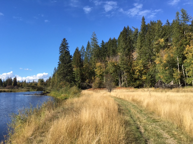
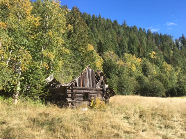
You’ve probably driven past this intersection many times without a second thought. It’s located about five miles east of Sandpoint where Shingle Mill Road joins Highway 200. It’s usually a pretty quiet spot today, but more than once in the past, this place was hopping. And it was Dr. Hendryx who laid the foundation for the boom times from 1885-1892.

When we last left Dr. Wilbur A. Hendryx, he was heading east to set up a new corporation to finance the development of the Blue Bell Mine in British Columbia. He and his brother, Andrew B. Hendryx, joined with E. W. Herrick of Minneapolis and Charles E. Bristol of Ansonia, Connecticut, to form the Kootenay Mining & Smelting Company (KM&S) in late 1884. Dr. Hendryx became the general manager and he was the company’s sole representative in Idaho and British Columbia. In addition to developing the mine, he set about improving transportation and establishing a supply point.

A centuries-old trail ran from this point, known as Mud Slough, north to the Kootenai River near present-day Bonners Ferry. After the Northern Pacific Railroad completed its line across the Idaho Panhandle in 1882, this became a logical place for a station to unload passengers and freight bound for points north.

Robert E. Sproule, the discoverer of the Blue Bell Mine, was quick to see the potential for an improved transportation route to connect his mining interests in Canada with the new railroad in Idaho. He applied for a franchise to upgrade the trail into a toll road, and the Kootenai County* commissioners granted his petition in July 1883. Probably before any road work was done, Sproule sold this franchise to Hendryx in the fall of 1884 and Hendryx, in turn, transferred ownership to the KM&S.

The company completed the road in 1885, allowing wagons to haul goods from the railroad to Bonners Ferry. The county commissioners finally agreed to purchase the toll road from KM&S in April 1889, turning it into a county road and ending years of complaints from residents of the Kootenai Valley. KM&S had two steamboats operating on the Kootenai River to carry freight and passengers from Bonners Ferry to the mines at Kootenay Lake in British Columbia.

1188_2

1885 map of Kootenai, Idaho (Bonner County Historical Museum Archives)

In conjunction with this important road, Hendryx laid out a new town of Kootenai on the flat land above Mud Slough. The plat (shown at  right), submitted to the county in June 1885, showed a neat grid of streets, with First, Second, and Third Streets running parallel to the Northern Pacific tracks and intersecting Kootenai and Michigan Avenues. Most of this was just a paper dream, however, and a later map (see below) showed most buildings clustered along Kootenai and Railroad Avenues.

During the summer and fall of 1885, Hendryx had crews clearing trees and milling lumber with a portable sawmill. They constructed a number of buildings in the townsite, many of them designed to serve the needs of KM&S. By the following June, the new town included a depot, post office, hotel, and store, in addition to the company’s warehouse, blacksmith shop, assay office, stables, and equipment sheds.

While Kootenai got its start by connecting a mining district in British Columbia with the Northern Pacific in Idaho, it took a second railroad to make the little town boom. The Great Northern Railway Co. announced plans in 1889 to extend its existing tracks from mid-Montana all the way to the coast, following the Kootenai River as far as Bonners Ferry before heading south to Sandpoint. Since the town of Kootenai on the Northern Pacific provided an existing railroad connection, it was logical that it would become the primary supply point once construction crews began building the new rail line through Idaho.

Things began picking up by early 1890 as entrepreneurs anticipated the start of construction. James Dolan opened the Miners and Traders Bank in Kootenai in December 1889 and one month later the town had a newspaper reporter. Despite its still-small size, the outlook for Kootenai looked more promising than nearby Sandpoint, and the newspaper suggested in February 1890 that Sandpoint might become a suburb of Kootenai.

The real boom hit in 1891 when thousands of men descended on the Idaho Panhandle to work on the giant construction project. Equipment and supplies for 150 miles of railroad work arrived in Kootenai, to be unloaded from freight cars parked on two long sidings. The Kootenai depot recorded $35,000 in business in just over three months, from April to mid-July. During the same time, crews unloaded supplies from close to 300 Northern Pacific freight cars and loaded nearly 250 cars with outgoing freight including railroad ties, bridge timbers, and telegraph poles. Teamsters headed north on the former toll road, hauling freight wagons loaded with everything from bacon and beans to railroad spikes and dynamite.

Screen Shot 2016-02-15 at 11.55.04 AM

Map of Kootenai, Idaho, June 1891 (Sanborn-Perris Map Co., Limited, New York)

During this time, Kootenai’s population grew rapidly. While the key for the above map shows the population in June 1891 at 150, the newspaper reported 500 people there by mid-July 1891. Most were single males whose paychecks supported an incredible number of saloons. A close look at the above map shows twelve saloons, three restaurants, and two hotels, along with several stores, a laundry, and a barber. Some of the business people probably lived in their commercial buildings since the map shows only fifteen dwellings (indicated on the map by the letter D).

Screen Shot 2016-02-15 at 11.55.50 AM

Detail of the above map.

Railroad contractors kept up a brutal pace of construction during the fall of 1891 and Kootenai continued to boom as supplies poured in. Saloon keepers were raking in the money, likely knowing full well that the boom times could not last. For instance, the Kootenai Resort offered nightly music and dancing along with an extensive stock of liquors and cigars.  Billey and Charley’s Resort had similar offerings, while the nearby Palace Theater featured a variety troupe nightly. When two more bars opened in October 1891, the newspaper commented, “Kootenai is bound to see good times this fall.”

Screen Shot 2016-02-15 at 5.10.08 PM

Ad from the Kootenai Herald, 22 August 1892, 5:5.

The good times did not last long, however, and it was all over by early 1892. The Great Northern construction moved westward from Sandpoint toward Priest River, and those towns benefited at the expense of Kootenai. A Sandpoint newspaper, perhaps biased in its reporting, printed an obituary in March 1892: “Died – In the county of Kootenai and the state of Idaho, the village of Kootenai,” the announcement read. “It lived and died a natural death. Funeral will take place during March. Friends of the deceased are all invited.” Two surveyors with the General Land Office confirmed these observations later that year, noting that the town’s population had dropped from several hundred to no more than 75. Three years later, the post office was abandoned and most of the buildings torn down for the lumber.

GLO map T57N R1W, 14 May 1894, surveyed Nov.-Dec. 1892

Portion of General Land Office Map of Township 57 North, Range 1 West, surveyed November-December 1892.

The final blow came in May 1896 when a fire started in a vacant building and burned most of what remained of Kootenai. One of the few houses spared was Dr. Hendryx’s former home, located across the tracks from the rest of town. It was then occupied by Alfred Boyer who lived there for so many years that Mud Slough became known as Boyer Slough and a new post office also took the Boyer name. As memories of the short-lived but lively town of Kootenai faded, a new community coalesced a few miles west to support the new Kootenai Bay Lumber Company. The new town took the Kootenai name and it remains there today.

While it might seem that Dr. Hendryx had left the area long before, that was not the case. He likely spent a good deal of his time at the Blue Bell Mine on Kootenay Lake during the late 1880s, but Hendryx was still well known in this area. As Idaho approached statehood, counties around the large territory designated representatives to the Constitutional Convention, to be held in Boise in July 1889. Dr. Wilbur A. Hendryx was one of three men selected to represent Kootenai County. Henry Melder attended the entire convention, Albert Hagan arrived in time to make a significant contribution to the proceedings, but Dr. Hendryx was not to be seen. Instead of heading south to Boise to represent his county, he went north to Kootenay Lake to deal with his mining operations. The local newspaper railed against Hendryx for failing his duty, but it is doubtful that his business suffered. Hendryx remained involved in the Blue Bell Mine during the early 1890s. KM&S constructed a mill and smelter at Pilot Bay on Kootenay Lake in 1895 but it had limited success and was in receivership by 1899.

Hendryx returned to his practice of medicine, at least intermittently. He was living in Los Angeles by 1895 and was listed as married in the 1900 census. He was connected with the Hendryx Electro Cyanide Company in Denver in 1905 and the Hendryx Cyanide Machinery Company in New York from 1914-1917. He died in 1918 and was buried in New York City.

Both Dr. Hendryx and the original location of Kootenai are all but forgotten. Give them a nod of acknowledgement next time you pass Shingle Mill Road.

* Kootenai County initially encompassed most of North Idaho, including what are now Kootenai, Benewah, Bonner, and Boundary Counties.

Sources:

“On Lake Pend d’Oreille,” Northwest Magazine, vol. 4, no. 6 (June 1886), 1:2-3; Kootenai County, Commissioners Journal, Book A:42, 63, 86, 117, 122, 175, 211, 298, 411; “Plat of the Town of Kootenai, Kootenai County, Idaho Ter.,” 12 June 1885, original on file, Bonner County Historical Museum Archives;  “Kootenai On A Boom,” Kootenai Courier, 21 December 1889, 3:3; “Kootenai Kullings,” Kootenai Courier, 18 January 1890, 2:3-4; “Kootenai Kullings,” Kootenai Courier, 8 February 1890, 3:3; “City of Kootenai,” Kootenai Herald, 11 July 1891, 4:2-3; “Kootenai Is In It,” Kootenai Herald, 11 July 1891, 8:2-3; Ad for Billey and Charley’s Resort, Kootenai Herald, 22 August 1891, 5:5; “Good For Kootenai,” Kootenai Herald, 10 October 1891, 4:2; “The Enterprising Man’s Column,” Kootenai Herald, 14 November 1891, 4:2-3; Map of Kootenai, Idaho, June 1891 (New York: Sanborn-Perris Map Co., Limited, 1891); Map of Township No. 57 North, Range No. 1 West of the Boise Meridian (Boise: Surveyor General’s Office, 1894); Amos D. Robinson and Jas. E. Dike, Field Notes of the Survey of Subdivisions and Meanders of Fractional T.57N., R.1W., 9/529, 10/530, http://www.glorecords.blm.gov; Obituary, Pend d’Oreille News, 12 March 1892, 4:3; “Kootenai In Ashes,” Hope Examiner, 1 May 1896, 2:1; “Local Paragraphs,” Northern Idaho News, 20 November 1903, 10:5; Kootenai Courier, 6 July 1889, 2:1; Elsie Turnbull, “Old Mines in the West Kootenay,” British Columbia Historical Quarterly, vol. 20, no. 3-4 (July-October 1956), 147-157; Los Angeles, California, City Directory, 1895:689, 1897:446, 1900:381, 1903:588, accessed through Ancestry.com; Twelfth Census of the United States, Los Angeles township, Los Angeles City, Ward 3, 1 June 1900, Sheet 1B; Denver, Colorado, City Directory, 1905, accessed through Ancestry.com; New York, New York, City Directory, 1914:283, 1916, 1917:988, accessed through Ancestry.com; Certificate of Death, Dr. Wilbur A. Hendryx, File No. 96760, Commonwealth of Pennsylvania, Department of Health, Bureau of Vital Statistics, 21 September 1918, accessed through Ancestry.com.

Posted in Uncategorized | Tagged , , , , , , , , , | 2 Comments

Dr. W. A. Hendryx and Robert E. Sproule

I thought I’d start out the new year by writing a simple story about Dr. W. A. Hendryx. After all, I’ve run into Dr. Hendryx quite a few times while reading old newspapers or rummaging through musty records in the county courthouse. I’ve never met him – he died in 1918 – but over the years his name has popped up in connection with a toll road, the original Kootenai townsite, and the Idaho Constitutional Convention. I’d also seen another name, R. E. Sproule, tied to the toll road but I’d never given him a second thought. When I looked into Dr. Hendryx a bit more, however, I found him connected to Sproule and before I knew what was happening, I was sucked into Sproule’s complex story that included contested mining claims and murder. Here’s a start on that story, with first a bit of background on Hendryx.

Wilbur Alson Hendryx was born in Connecticut in 1849. Twenty-one years later he still lived at home with his parents and worked as a butcher. (Whether or not this job prepared him for a career in medicine is a matter of conjecture!) He received his medical degree from Rush Medical College in Chicago in 1874 and practiced medicine off and on for the rest of his life.

Map_Arrow_and_Kootenay_Lakes,_British_Columbia,_1895

Map of Arrow and Kootenay Lakes, British Columbia, 1895. See below for credit.

Screen Shot 2016-01-26 at 8.45.42 AM

Portion of map showing Blue Bell Mine and the smelter at Pilot Bay.

Sometime in 1884, Dr. Hendryx came to North Idaho where he met Robert Evan Sproule, the owner of an especially promising mining claim on the eastern shore of Kootenay Lake in British Columbia. Sproule had located the Blue Bell claim in the summer of 1881 and legally registered it with the proper authorities the following year. He was not alone in his search for promising minerals and soon ran into competition from three prospectors who were backed by a wealthy consortium. One of the men, Thomas Hammill, jumped Sproule’s claim after he left in October 1882. During a lengthy trial the following summer, Sproule and his associates prevailed only to have the case appealed to the Supreme Court of British Columbia. When the court ruled in the spring of 1884, Sproule once again won his claim to the Blue Bell and must have felt satisfied to hear Hammill condemned for his illegal claim jumping. Any satisfaction soon faded, however, when one of Sproule’s partners failed to pay the fines and court costs connected with other related litigation. The court took possession of the partner’s one-third share in the Blue Bell and auctioned it off that summer – to none other than Sproule’s nemesis, Thomas Hammill and his backers.

Mr. Sproule was in a jam and knew that large amounts of money would be needed to develop the Blue Bell mine. His primary asset was his two-thirds share of the mining claim. Sproule also had acquired a franchise to build a toll road running between Mud Slough, on the northern shore of Lake Pend Oreille, and the Kootenai River near Bonners Ferry, Idaho. In the fall of 1884, Sproule and Hendryx reached some sort of agreement that gave Hendryx the franchise for the toll road along with a partial interest in the Blue Bell. While I was unable to find any records showing what Sproule got out of the deal, it is clear that Hendryx planned to develop the Blue Bell and thus greatly benefit Sproule financially.

That same fall, Hendryx transferred the toll road franchise, along with his interests in the Blue Bell, Silver King, Black Hawk, and Surprise claims on Kootenay Lake, to the Kootenay Mining & Smelting Company. This new corporation was organized by Dr. Hendryx and other investors, including Andrew B. Hendryx, of New Haven, Connecticut. Andrew, Wilbur’s older brother, was part of the successful firm of Hendryx & Bartholomew, later changed to the Andrew B. Hendryx Co. His business manufactured a line of bird cages to house the small birds that were so popular during the Victorian era. Products also included a number of models of fishing reels, with Andrew B. Hendryx holding many patents for their design. With such a successful business, Andrew likely provided much of the capital needed to fund the mining development on Kootenay Lake.

Andrew B. Hendryx catalog 1904

Title page from Andrew B. Hendryx Co. catalog, 1904

As the new corporation was organizing in the winter of 1884-1885, Mr. Sproule was nursing a couple of grudges. Of course he disliked Thomas Hammill and his backers who, through unexpected circumstances, had ended up with part of the Blue Bell claim. Sproule also was angry with a man who had once been his friend and advocate. William A. Baillie-Grohman was a wealthy European gentleman who enjoyed both big game hunting and outdoor life. He traveled around the American West where he hunted and wrote prolifically about his experiences. He also was instrumental in some early development in the Kootenay region of British Columbia.

Baillie-Grohman became acquainted with Mr. Sproule by early 1883 when he agreed to help with his original claim dispute. They stood together during the six-week trial at the mining camp and celebrated their win. When the cases were appealed to the Supreme Court of British Columbia, however, Baillie-Grohman had to return to England for business. After Sproule ultimately lost part of the Blue Bell claim, he blamed both Baillie-Grohman and Thomas Hammill and, according to one account, was heard making threats against both men.

Sproule, hiding beside a trail near Sandpoint, took his first shot – literally – at Baillie-Grohman. Fortunately for his intended victim, Sproule missed when Baillie-Grohman’s horse shied at the sound of the rifle shot. The frightened horse and rider high-tailed it into town and took refuge in a shed behind the E. L. Weeks & Co. store. Baillie-Grohman considered Burt Weeks to be one of the few upstanding citizens in Sandpoint, describing the rest of the town as “one of the ‘tough’ towns in the tough territory of Idaho . . . .” Needless to say, Baillie-Grohman spent a restless night but managed to catch the morning train to Rathdrum where he planned to swear out a complaint against Sproule. His plans – and his life – were nearly cut short when his enemy jumped onto the train at the last minute. Before he could do anything, the unarmed Baillie-Grohman found himself with “the muzzle of Sprowle’s [sic] cocked -45 Colt, a big frontier six shooter . . . within 4m. of my forehead.” He was told to get off the train at Algoma, “a wretched siding, where the station shed was the only building, and the two railway officials the only inhabitants . . . .” Fortunately, as the train slowed to stop, the conductor arrived in their car and Sproule melted away. The two men never saw each other again.

Thomas Hammill, however, was not as lucky. When he showed up at the disputed Blue Bell claim on June 1, 1885, Robert Sproule allegedly shot him in the abdomen. By the time Hammill died later that day, Sproule was on his way toward the border and safety in Idaho. He was captured just north of the border, however, and taken to Victoria where he was tried, convicted, and sentenced to die. He appealed his case to the Supreme Court but ultimately lost. He was hanged in Victoria on October 29, 1886, and buried in the jail yard.

While Sproule’s sad case worked its way through the Canadian courts and made news on both sides of the border, the Kootenay Mining & Smelting Co., with Dr. Hendryx as its manager, set to work developing the Blue Bell mine. This project led to the establishment of the new town of Kootenai, east of Sandpoint on the Northern Pacific Railroad; the development of a wagon road connecting Kootenai to Bonners Ferry and the Kootenay mining region of British Columbia; and the eventual construction of a smelter at Pilot Bay on Kootenay Lake to process the galena ore.

After this diversion from my original topic, I’ll get back to Dr. Hendryx, early Kootenai, and the toll road soon.

Sources:

Ninth Census of the United States, Seymour, New Haven County, Connecticut, 1870, page 31; Directory of Deceased American Physicians, 1804-1929, accessed through Ancestry.com; D.M. Wilson, “East Shore of Kootenay Lake, B.C.: History,” 2001, revised 2010, http://www.crowsnest-highway.ca/cgi-bin/citypage.pl?city=east_shore#1, accessed 15 January 2016; Quit Claim Deed, Robert E. Sproule to W. A. Hendryx, 8 November 1884, Bonner County, Bills of Sale, Book 1:7; Declaration of Trust, Wilbur A. Hendryx to Kootenai [sic] Mining & Smelting Company, signed 8 October 1884 and recorded 6 December 1884, Bonner County, Bills of Sale, Book 1:6; “The Andrew B. Hendryx Company,” http://www.retropeacock.com/hendryx.html#.Vp_MbVJ0FaV, accessed 19 January 2016; “The Andrew B. Hendryx Company,” http://www.oldreels.com/hendryx.htm, accessed 19 January 2016; Linda Gross, “The Andrew B. Hendryx Company Knew Why Caged Birds Sing,” http://www.hagley.org/librarynews/andrew-b-hendryx-company-knew-why-caged-birds-sing, accessed 19 January 2016; “William Adolph Baillie Grohman,” https://en.wikipedia.org/wiki/William_Adolf_Baillie_Grohman, accessed 23 January 2016; W. A. Baillie-Grohman, Fifteen Years’ Sport and Life in the Hunting Grounds of Western American and British Columbia (London: Horace Cox, 1900), 231-251, quotations from p. 248; “Robert Evan Sproule,” Washington, Pierce County, Probate Case Files, Case 1080, Box 15, Vol. 1069-1088, 1855-1911, accessed on Ancestry.com, Washington, Wills and Probate Records, 1807-1997 (database online), Image 133-134, 136-137, 140-146, 158-160; “Sproule Must Die,” New York Times, 1 October 1886; “The Case of Sproule,” New York Times, 28 October 1886.

Illustrations:

The Andrew B. Hendryx Company catalog, 1904: http://babel.hathitrust.org/cgi/pt?id=hvd.hwh2pw;view=1up;seq=10

Map of Arrow and Kootenay Lakes, British Columbia, 1895: https://commons.wikimedia.org/wiki/File%3AMap_Arrow_and_Kootenay_Lakes%2C_British_Columbia%2C_1895.JPG

Posted in Uncategorized | Tagged , , , , , , , , , , , , | 2 Comments

What’s with Main Street?

Streets in Sandpoint generally intersect at right angles to form a tidy grid pattern – except for Main Street. It slashes a bold diagonal line across the grid, leaving a scatter of triangular blocks in its wake. What’s the matter with Main Street?

IMG_2149

Looking west at small triangular park on Florence Avenue, with Main Street on left and Alder Street on right.

The story begins back in 1892 when the tiny community of Sand Point was located on the east side of Mill Creek, now known as Sand Creek. Frame stores, hotels, and houses lined the railroad tracks for several blocks, mostly south of the Northern Pacific depot. A low water bridge crossed the creek and a rough road cut diagonally up the bank (behind today’s Panida Theater) to the flat land in what is now downtown Sandpoint. Just a handful of people lived on the west side of the creek at that time, spread out on their 160-acre claims in the forest. They included J.L. Prichard, Jack Waters, Wilton B. Dishman, and J.R. Law.

Portion of Map of Township No. 57 North, Range 2 West, Boise Meridian, Idaho (surveyed 1892, approved 1894). Note road running from the Great Northern station (upper left) to town.

The early 1890s were a lively time for the small town on Lake Pend Oreille. Officials for the recently completed Great Northern Railway decided to build a depot beside the tracks, about a mile and a half west of Sandpoint. Savvy business people immediately saw the need for a road to connect the two depots to facilitate the transfer of both freight and passengers. Construction was well under way by late July 1892, and just over a month later, Mr. Dishman was advertising his stage line running between the Northern Pacific and Great Northern stations.

IMG_2040

Ad from Pend d’Oreille News, 3 September 1892, 5:3.

It didn’t take long for people to find fault with the new road. By October 1892 they complained that the “present road is very crooked, full of ruts and stumps and when the wet season comes on a wagon will sink to the hubs.”  Concerned citizens asked the county commissioners to appropriate $500 for the county road between “East Sand Point and West Sand Point.” The commissioners approved $350 for the project.

William Ashley Jr., the county surveyor, laid out the road to run “as straight as [his] instruments could make it,” starting at the top of the slope “just beyond the bridge across the creek and coming out close to the G.N. depot.” Benjamin Butler contracted with the county to build the road but sublet the work to Mr. Prichard. He soon had a crew of men working through the bad weather in November 1892 to clear a fifty-foot right-of-way and finish a sixteen-foot road, with all of the stumps removed. Apparently the work continued into the following spring because Mr. Butler did not bill the county until July 1893. The county gave final approval for the new road in October 1893. This became our Main Street.

The rest of the streets in town didn’t get laid out for several more years. Lorenzo D. Farmin acquired Prichard’s claim and platted part of it for a new townsite in 1898. When he laid out his neat grid of streets, they crossed the well-established county road at funny angles, giving us small parks and difficult intersections today.

PTDC0008

Original Plat of Sandpoint, Idaho, 1898.


Side note: Wilton Dishman and his brother, Addison, moved in the mid-1890s to the Spokane area where they established the small community of Dishman. While it is now part of the city of Spokane Valley, the Dishman name remains on some businesses.

Sources:

From Depot to Depot, Pend d’Oreille News, 23 July 1892, 4:2; Telephone Line, Pend d’Oreille News, 30 July 1892, 4:2; Ad, Pend d’Oreille News, 3 September 1892, 5:3; Petition for an Important Road, Pend d’Oreille News, 8 October 1892, 5:3; A Road Surveyed, Pend d’Oreille News, 22 October 1892, 4:3; Work Has Commenced, Pend d’Oreille News, 19 November 1892, 5:1; Flourishing Sand Point, Pend d’Oreille News, 4 March 1893, 2:1-2; Bonner County, Commissioners Journal, Book 1: 29, 30, 34, 35; Kootenai County, Surveyor’s Record, Book 1:15; Dishman now part of Spokane Valley, Spokesman-Review, 28 September 2015, A5.

Posted in Uncategorized | Tagged , , , , , | Leave a comment

Pend d’Oreille, Sand Point, or Both?

Can a town have two names at the same time? In the case of Sandpoint, the answer is, “Yes . . . but it’s complicated.”

Several sources – quoted often – say that the town’s name at one time was Pend d’Oreille. Ella M. Farmin noted in her memoir that her husband’s land claim (where downtown Sandpoint is today) was across the creek from the Northern Pacific station and “the village of Pend d’Oreille.” The Farmins had lived in town barely a year when the name officially changed to Sandpoint, but she later remembered that some people, including herself, greeted the change with “disgust.”

The trusty 1903 History of North Idaho also tells us that both the town and the railroad station were known as “Pend Oreille.”

Screen Shot 2015-11-16 at 9.33.11 AM

History of North Idaho, page 792.

The Northern Pacific Railroad may have called the station Pend d’Oreille at some point since that is the name shown on the General Land Office map, surveyed in the fall of 1892.

GLO T57N R2W 1894

Map of Township No. 57 North, Range No. 2 West, Boise Meridian, Idaho (surveyed 1892, approved 1894)

The surveyors who made the above map noted both of the town’s names in their field notes, casting some doubt on any claim that Pend d’Oreille was the accepted name.

Field notes p. 430

Excerpt from surveyor’s field notes, 1892

Indeed, this doubt was well founded. From all of the sources I have seen, I can say with some confidence that the Pend d’Oreille name applied only to the post office. It was officially known by this name from 1882 through the end of 1893 when the name changed to Sandpoint (all one word). I have been unable to find anything else to suggest that town of Sandpoint was commonly known as Pend d’Oreille. On the other hand, there is abundant evidence that the name was always some version of Sandpoint (Sandy Point, Sand Point, or Sandpoint).

This name comes from the prominent point of sand formed where Sand Creek runs into the lake. It was a traditional camp for Kalispel people who called it qapqape’ or “sand.” Early travelers noted this landmark when passing through the area, and we continue to enjoy the “sandy point,” now better known as the Sandpoint city beach.

During the peak of construction on the Northern Pacific Railroad, there was a camp for workers at Sandpoint. Letters from engineers stationed there in 1881 bore the place name of either Sand Point or Sandy Point.

Screen Shot 2015-11-16 at 8.20.21 PM

Letter written from Sand Point, October 20, 1881.

A year later, a map of mineral lands along the new railroad line showed Sand Point, just across the lake from Ventnor.

Screen Shot 2015-11-16 at 8.24.25 PM

Portion of 1882 map showing Northern Pacific Railroad (red line) and Sand Point

In August 1883, a traveler wrote about his trip on the newly completed Northern Pacific Railroad. They ate breakfast “at Sand Point, a station on the north shore of Pend d’Oreille lake . . . . This place has about 50 people and half as many houses.” A travel book, published that same year, noted that Sand Point “was a place of importance during the time of construction, and probably will retain its advantage to some extent, as it connects with the country on the north. It is also a good point to lie over for a day’s hunting, or for catching some of the trout with which the lake abounds.”

In 1887, a group of young Englishmen, with a taste for adventure as well as a good sense of humor, ended their “ramble” in British Columbia and came south to pick up the train in Sandpoint. They described the small community below:

Screen Shot 2015-11-16 at 8.37.15 PM

From B.C. 1887: A Ramble in British Columbia, page 362.

I’ll end with an ad from the Pend d’Oreille News,  a short lived newspaper that was published from February 1892 to April 1893. The masthead listed the place of publication as “Sand Point (Pend d’Oreille P.O.) Idaho.” The news articles always called the town Sand Point, and ads listed Sand Point as the place of business.

IMG_2103

Pend d’Oreille New, 13 February 1892, 4:4-5.

All of the ads, that is, except one from J. L. Prichard who owned a small store in what he called Pend d’Oreille . . .

IMG_2105

Pend d’Oreille News, 13 February 1892, 4:5.

. . . and just happened to be the town’s postmaster. Like I said, it’s complicated!

[Apologies for the poor quality of the newspaper photos, taken from a microfilm reader screen.]

Sources:

John M. Henderson, William S. Shiach, and Harry B. Averill, An Illustrated History of North Idaho, Embracing Nez Perces, Idaho, Latah, Kootenai and Shoshone Counties, State of Idaho (Spokane: Western Historical Publishing Company, 1903), 792;  Ella M. Farmin, “The Days of a Woman, written by Herself,” no date, 61, File: Farmin, Ella, Bonner County Historical Museum; Map of Township No. 57 North, Range No. 2 West of the Boise Meridian (Boise: Surveyor General’s Office, 1894); Amos D. Robinson and Jas. E. Dike, Field Notes of the Survey of Subdivisions and Meanders of Fractional Township 57 North, Range 2 West of the Boise Meridian, Idaho, 1892, 35/430, http://www.glorecords.blm.gov; “Sandpoint Post Office, Bonner County, Idaho,” on Postmaster Finder, http://webpmt.usps.gov/pmt003cfm, accessed 12 October 2015; “To Be Known as Sandpoint,”Spokane Review, 3 January 1894, 4:1; Verne F. Ray, “Native Villages and Groupings of the Columbia Basin,” Pacific Northwest Quarterly 27 (1936): 129; John D. Latour, Sand Point, to H. M. McCartney, Spokane Falls, 20 October 1881, Records Box 134.L.14.2F, Engineer Department MT ID, Northern Pacific Railway Collection, Minnesota Historical Society; J. M. Tiernan, “Map showing Geological Formations and Mineral Lands near the Northern Pacific Railroad in Northern Idaho & Washington Territories,” 1882, Archives and Special Collections, University of Idaho; Columbia Chronicle, 4 August 1883, 1:5; Henry J. Winser, The Great Northwest: A Guide-Book and Itinerary for the Use of Tourists and Travellers [sic] over the Lines of the Northern Pacific Railroad, the Oregon Railway and Navigation Company and the Oregon and California Railroads (New York: G.P. Putnam;s Sons, 1883), 209; J. A. Lees and W. J. Clutterbuck, B.C. 1887: A Ramble in British Columbia (London: Longmans, Green, and Co., 1892), 362; Pend d’Oreille News, 13 February 1892, 4:4-5.

Posted in Uncategorized | Tagged , , , , , | Leave a comment

Who Was Robert Weeks?

Screen Shot 2015-11-16 at 9.22.27 AM

Most histories of Sandpoint, Idaho, include a few lines about Robert Weeks. He opened the first store in 1880, we are told, and also owned a hotel, bar, and sawmill. Meanwhile his son Barton ran a general store with his wife, operating under the name of E. L. Weeks & Co.  I and countless others have taken these statements as true, repeating them over and over. After all, the information comes from the trusted 1903 History of North Idaho, a massive volume full of wonderful history.

Screen Shot 2015-11-16 at 9.29.34 AM

History of North Idaho, page 792

It turns out that you shouldn’t always believe what you read, even in impressively large books. Their names are not Robert and Barton, they did not arrive in 1880, and the store was named for the woman who ran it. Adding insult to injury, they were Californians!

I learned this after a descendant of the Weeks family sent some photographs and information to the Bonner County Historical Society. After digging into county records and old newspapers, I pieced together a more complete picture of Mr. Weeks and his family. Here’s what I know so far:

Construction of the Northern Pacific Railroad generated a great deal of activity in the Sandpoint area in the early 1880s. Thousands of men were needed to clear right of way, grade roadbed, build bridges, and lay tracks. The work moved eastward from Spokane into the Idaho Panhandle early in 1881, heading for Lake Pend Oreille where a long wooden trestle was to be constructed across the outlet of the lake at Sandpoint. This is where the Weeks family joins the picture.

The Northern Pacific contracted with individuals and small firms to operate portable sawmills at various points along the rail line. Robinson Jones Weeks, a rancher near La Honda, California, secured a contract to mill timbers on the northern shore of Lake Pend Oreille where the trestle was being built. He brought his portable sawmill, tools, and horses with him from California, arriving at the lake in the spring of 1881. Two of his sons, Burt and Asa, came with him, along with an experienced sawmill crew. They had the mill up and running by early summer.

Burt Weeks

Burt D. Weeks, from photocopied portion of History of San Mateo County, California, vol. 2 (1928), page 321

Other members of the Weeks family joined them within a short time, moving from California to the tiny town that was just taking shape beside the Northern Pacific tracks. This group included Robinson’s wife and daughter, Cordelia and Ella, and Burt’s wife and son, Emma and Percy. The small boy was just two years old at the time.

They arrived at the peak of railroad construction when thousands of men were busy grading the roadbed east from Sandpoint. Once the lake trestle was finished, the work proceeded rapidly, and the tracks had almost reached Montana before the end of 1882.

As the railroad construction moved eastward, the elder Weeks couple prepared to return to California. They had acquired considerable assets during their short time at Sandpoint, and they sold these before the end of August 1882. Their properties included the two story Lake View Hotel, sold to son Asa; a restaurant and stable, sold to Harry Baldwin (another Californian); and the sawmill, sold to two men from Spokane. The mill’s sale price of $3,934.80 included the equipment and buildings for the sawmill and planing mill, “tools of every name and nature” relating to the mills, and the booms and piers in the lake adjacent to the mill site.

Burt and Emma Weeks stayed in Sandpoint for the next ten years. The enterprising Emma ran the general store that carried her name: E. L. Weeks & Co. Percy was joined by a sister, Rena Idaho, whose middle name proudly proclaimed her place of birth. Burt’s work often took him away for long stretches of time, but his wife managed to keep the store while caring for two small children. In conjunction with her business, Emma served as a Wells Fargo agent and worked as the postmaster from 1884-1891. Before they left, they had invested in a second store in the nearby town of Kootenai.

History of San Mateo County

Excerpt from biography of Burt D. Weeks in History of San Mateo County, California, vol. 2 (1928), page 320

Burt and Emma returned to California with their children in 1891. They sold their stores, packed their belongings, and likely left on the train, riding on the railroad they helped to build. They have been long forgotten here in Sandpoint, hidden behind a confusion of jumbled information and misspelled names. It’s probably time to give these Californians the recognition that is due.

Sources:

John M. Henderson, William S. Shiach, and Harry B. Averill, An Illustrated History of North Idaho, Embracing Nez Perces, Idaho, Latah, Kootenai and Shoshone Counties, State of Idaho (Spokane: Western Historical Publishing Company, 1903), 792;  History of San Mateo County, California, vol. 2 (Chicago: S. J. Clarke Publishing Company, 1928), 320-323, 610-612; Norma Hohl, partial transcript of taped interview, no date, 32-33, 40, Biography Files, file: Weeks, Bonner County Historical Museum; “A Trip to Lake Pend d’Oreille,” Northwest Tribune, 3 June 1881, 2:5; “Sandpoint Post Office, Bonner County, Idaho,” on Postmaster Finder, http://webpmt.usps.gov/pmt003cfm, accessed 12 October 2015; “Local and Personal,” Kootenai Herald, 18 July 1891, 5:2; Kootenai County, Deed Record, Book A:24-26, 59, 72.

Additional information on the Weeks family can be found at http://williamsranchboarding.com/ranch_history

Posted in Uncategorized | Tagged , , , , , , , , , | 1 Comment