
Streets in Sandpoint generally intersect at right angles to form a tidy grid pattern – except for Main Street. It slashes a bold diagonal line across the grid, leaving a scatter of triangular blocks in its wake. What’s the matter with Main Street?
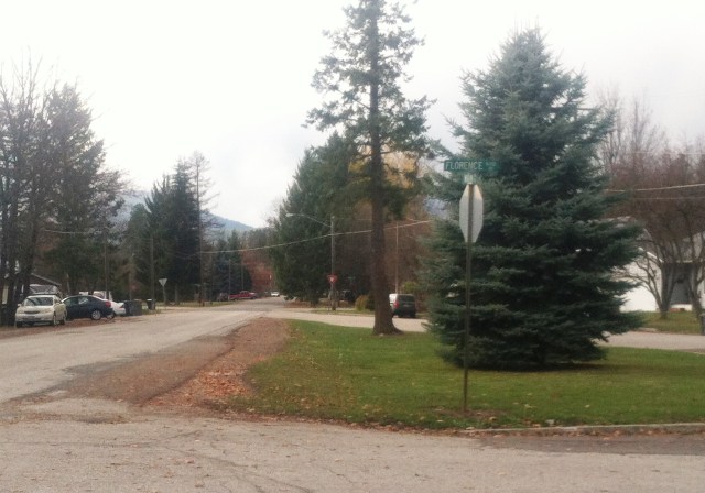
Looking west at small triangular park on Florence Avenue, with Main Street on left and Alder Street on right.
The story begins back in 1892 when the tiny community of Sand Point was located on the east side of Mill Creek, now known as Sand Creek. Frame stores, hotels, and houses lined the railroad tracks for several blocks, mostly south of the Northern Pacific depot. A low water bridge crossed the creek and a rough road cut diagonally up the bank (behind today’s Panida Theater) to the flat land in what is now downtown Sandpoint. Just a handful of people lived on the west side of the creek at that time, spread out on their 160-acre claims in the forest. They included J.L. Prichard, Jack Waters, Wilton B. Dishman, and J.R. Law.
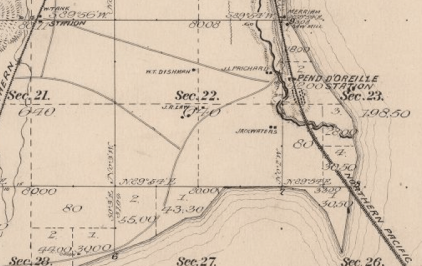
Portion of Map of Township No. 57 North, Range 2 West, Boise Meridian, Idaho (surveyed 1892, approved 1894). Note road running from the Great Northern station (upper left) to town.
The early 1890s were a lively time for the small town on Lake Pend Oreille. Officials for the recently completed Great Northern Railway decided to build a depot beside the tracks, about a mile and a half west of Sandpoint. Savvy business people immediately saw the need for a road to connect the two depots to facilitate the transfer of both freight and passengers. Construction was well under way by late July 1892, and just over a month later, Mr. Dishman was advertising his stage line running between the Northern Pacific and Great Northern stations.

Ad from Pend d’Oreille News, 3 September 1892, 5:3.
It didn’t take long for people to find fault with the new road. By October 1892 they complained that the “present road is very crooked, full of ruts and stumps and when the wet season comes on a wagon will sink to the hubs.” Concerned citizens asked the county commissioners to appropriate $500 for the county road between “East Sand Point and West Sand Point.” The commissioners approved $350 for the project.
William Ashley Jr., the county surveyor, laid out the road to run “as straight as [his] instruments could make it,” starting at the top of the slope “just beyond the bridge across the creek and coming out close to the G.N. depot.” Benjamin Butler contracted with the county to build the road but sublet the work to Mr. Prichard. He soon had a crew of men working through the bad weather in November 1892 to clear a fifty-foot right-of-way and finish a sixteen-foot road, with all of the stumps removed. Apparently the work continued into the following spring because Mr. Butler did not bill the county until July 1893. The county gave final approval for the new road in October 1893. This became our Main Street.
The rest of the streets in town didn’t get laid out for several more years. Lorenzo D. Farmin acquired Prichard’s claim and platted part of it for a new townsite in 1898. When he laid out his neat grid of streets, they crossed the well-established county road at funny angles, giving us small parks and difficult intersections today.
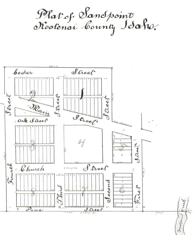
Original Plat of Sandpoint, Idaho, 1898.
Side note: Wilton Dishman and his brother, Addison, moved in the mid-1890s to the Spokane area where they established the small community of Dishman. While it is now part of the city of Spokane Valley, the Dishman name remains on some businesses.
Sources:
From Depot to Depot, Pend d’Oreille News, 23 July 1892, 4:2; Telephone Line, Pend d’Oreille News, 30 July 1892, 4:2; Ad, Pend d’Oreille News, 3 September 1892, 5:3; Petition for an Important Road, Pend d’Oreille News, 8 October 1892, 5:3; A Road Surveyed, Pend d’Oreille News, 22 October 1892, 4:3; Work Has Commenced, Pend d’Oreille News, 19 November 1892, 5:1; Flourishing Sand Point, Pend d’Oreille News, 4 March 1893, 2:1-2; Bonner County, Commissioners Journal, Book 1: 29, 30, 34, 35; Kootenai County, Surveyor’s Record, Book 1:15; Dishman now part of Spokane Valley, Spokesman-Review, 28 September 2015, A5.
